Line 5 of the Paris metro: List of stations, line map
Plan a journey

The line 5 of the Paris metro connects various points in the east of the capital located on a north-south axis from the station Place d'Italie, in the 13th arrondissement, at the Bobigny - Pablo Picasso station, which is located in Bobigny. The total length of this metro line is approximately 14.5 km. The total journey time from one terminus to the other is 34 minutes. The crossing of the Seine is done on a viaduct, at the level of the Gare d'Austerlitz. Line 5 has the particularity of connecting 3 Parisian stations: Gare d'Austerlitz, Gare de l'Est and Gare du Nord.
Line 5 was opened to the public in 1906. Before 1942, the route of line 5 was very different from what it is today: it left its terminus located at Etoile station (the current station Charles de Gaule-Etoile), took the current route of line 6 to Place d'Italie, and went up to the Gare du Nord (which was then its other terminus). Line 6 was then limited to the route between Nation and Place d'Italie. In 1942, it was decided that the southern terminus of line 5 would be at Place d'Italie and that line 6 would be extended to Etoile, using the old route of line 5.
The attendance of line 5 is approximately 114 million passengers per year, making it the eighth busiest line in the capital.
Subway frequency
On weekdays, the average waiting time between trains is two to four minutes during the day, seven to eight minutes after 8 p.m. Expect four to six minutes of waiting on Sunday during the day and ten minutes on the nights of Fridays to Saturdays, Saturdays to Sundays and the eves of holidays.
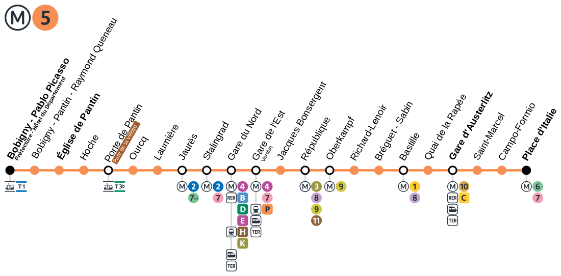 Map of line 5 of the Paris metro
List of stations on line 5 from terminus to terminus with connections to other lines on the network:
Bobigny Pablo Picasso
Bobigny-Pantin Raymond Queneau
Eglise de Pantin
Hoche
Porte de Pantin
Ourcq
Laumière
Jaurès
Stalingrad
Gare du Nord
Gare de l'Est
Jacques Bonsergent
République
Oberkampf
Richard Lenoir
Bréguet Sabin
Bastille
Quai de la Rapée
Gare d'Austerlitz
Saint Marcel
Campo Formio
Place d'Italie
Monuments de Paris | Musées de Paris | Salles de spectacle | aller au Parc Disneyland | aller au Château de Versailles | Grands magasins | Grandes écoles de Paris | Laboratoires de recherche | Hôpitaux de Paris et de région parisienne | Comment prendre le métro à Paris